2018 US Summer Forecast
6/14/2018 (Permalink)
2018 US summer forecast: Early tropical threat may eye South; Severe heat, drought to bake southern Plains
By Jillian MacMath, AccuWeather staff writer
May 02, 2018, 8:01:15 AM EDT
Share this article:
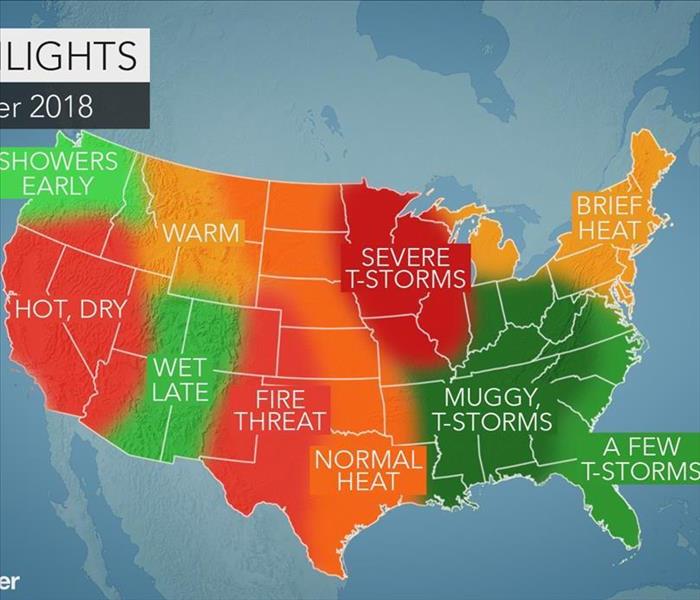
The Northeast and mid-Atlantic are in for a bit of everything this summer as the weather transitions between hot, humid and stormy.
Meanwhile, the southern United States will endure persistent storms and the threat for an early tropical impact.
In the Southwest and California, building heat and dryness will pose a high risk for wildfires.
Summer to bring heat, humidity and severe weather to Northeast, mid-Atlantic
From heat to humidity and severe weather, the Northeast and mid-Atlantic are set to experience a bit of everything this summer.
A few hot periods will take hold throughout the summer, though it won’t be persistent.
“I think there’s going to be surge later in June when we really start to feel some heat here in the Northeast. But will it stick around the whole summer? I don’t think that’s going to happen,” AccuWeather Expert Long-Range Forecaster Paul Pastelok said.
I-95 cities, including New York City, Boston and Philadelphia, are predicted to average close to normal with respect to the number of 90-degree days.
“Humidity-wise they’ll have to watch out for August. That may be up a little bit,” he said.
Severe weather could strike the northern mid-Atlantic states and eastern Ohio in June.
In July, that risk will shift farther northward.
Showers and thunderstorms to target the Southeast, Tennessee Valley, Gulf Coast
A barrage of showers and thunderstorms will target the Southeast, with Florida set to bounce back from severe drought conditions.
“They’re going to see some more action across the peninsula throughout the summer, which is good for them. I don’t see any dry conditions developing like we saw a couple of years ago,” Pastelok said.
Heavier storms will pose a risk for flooding with the Tennessee Valley and central Gulf coast facing the greatest threat.
Meanwhile, the entire region will be at risk for an early tropical impact.
“The last several years we’ve seen early tropical hits. I don’t see anything against that this year. Whereabouts? That’s a tough call. Anywhere is possible along the Gulf coast this year,” Pastelok said.
If a tropical system does impact the region, it’s more likely to be a tropical storm which would pose a greater risk for flooding rainfall, he said.
Severe weather to threaten the western Ohio Valley, Midwest, central/northern Plains
Short-term periods of high heat will blast the region in June, though temperatures will bounce up and down throughout the summer.
Severe weather will also target the first month of the season.
“June, I think, will be the month for the severe weather in the northern Plains,” Pastelok said. “It could linger a bit into July, but it will take a break before coming back in August.”
Stifling heat, drought to grip the southern Plains
Severe drought is predicted to continue across the southwestern Plains as intense heat dominates the summer.
June could end up being one of the top-five hottest on record for the region.
“Places like Dallas, Amarillo, Oklahoma City, those places are going to record above-normal temperatures and below-normal precipitation this summer,” Pastelok said.
The forecast could spell bad news for cattle farmers and consumers alike.
“The Plains drought could have an effect on agriculture and grazing for cattle,” Pastelok said. “The grass is not going to grow as much, so farmers are going to end up spending more on feed.”
High fire threat for the Southwest, California as heat and dryness build
Heat and drought will also stretch into the Southwest and California.
The fire threat in both of places will arrive early then remain high for a good part of the summer before rainfall increases into July and August.
Flash flooding is possible as precipitation increases for the interior Southwest and the central Rockies around the midpoint or latter half of the season.
Typical summer to transpire in Northwest, Rockies
Following a typical pattern for the Northwest and Rockies, late spring and early summer will remain mostly wet and cool.
The transition to warmer and drier summer weather won’t arrive until later in the season.
As the warmth increases in mid-July and August, drought conditions may develop east of the Cascades.
This could result in the threat for fires from late summer and into the fall season.


 24/7 Emergency Service